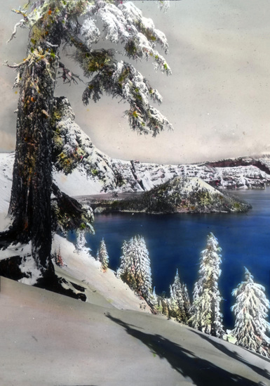
Crater Lake, formed by the collapse of Mount Mazama, sits near the Cascadia Subduction Zone where the Juan de Fuca plate subducts beneath North America. This tectonic process created the Cascade Range, including Mount Mazama. The lake’s formation 7,700 years ago resulted from a massive eruption, creating a caldera now filled with pristine blue water. This unique geological setting offers insights into volcanic processes and plate tectonics.
What is the Geological History of Crater Lake?

The story of Crater Lake begins with the formation of Mount Mazama, a composite volcano that was part of the Cascade Range in southwestern Oregon. This volcanic giant grew over hundreds of thousands of years through episodic eruptions and lava flows.
How Did Mount Mazama Form?
Mount Mazama’s formation can be broken down into several key stages:
- Initial Growth: Began approximately 420,000 years ago
- Building Phase: Multiple eruptions and lava flows over time
- Peak Height: Reached about 3,700 meters (12,000 feet) above sea level
- Pre-Climactic Activity: Increased volcanic activity leading up to the major eruption
What Caused the Climactic Eruption?
The climactic eruption of Mount Mazama, occurring around 7,700 years ago, was a cataclysmic event that reshaped the landscape. This eruption was triggered by:
- Magma chamber pressure buildup
- Tectonic stress from the nearby subduction zone
- Possible interaction with groundwater
The eruption’s effects were far-reaching:
| Effect | Description |
|---|---|
| Magma Ejection | Approximately 50 cubic kilometers expelled |
| Ash Distribution | Reached as far as central Canada |
| Caldera Formation | Collapse of the volcano’s summit |
| Regional Impact | Altered ecosystems and affected local populations |
How Does the Cascadia Subduction Zone Influence Crater Lake?

The Cascadia Subduction Zone (CSZ) plays a crucial role in the geological processes that shaped and continue to influence Crater Lake.
What is the Cascadia Subduction Zone?
The CSZ is a major tectonic boundary where the Juan de Fuca plate subducts beneath the North American plate. This subduction process:
- Generates magma through the melting of subducted rocks
- Fuels volcanic activity in the Cascade Range
- Creates potential for large-scale earthquakes
How Does Subduction Affect Volcanic Activity at Crater Lake?
The subduction process directly contributes to the volcanic nature of Crater Lake:
- Magma Generation: As the Juan de Fuca plate descends, it releases water, lowering the melting point of surrounding rocks
- Magma Rise: The newly formed magma, being less dense, rises through the crust
- Volcanic Arc Formation: This process creates the chain of volcanoes known as the Cascade Range
- Ongoing Influence: Continued subduction maintains the potential for future volcanic activity in the region
What Are the Unique Geological Features of Crater Lake?
Crater Lake boasts several distinctive geological features that make it a subject of scientific interest and natural wonder.
How Deep is Crater Lake and Why Does it Matter?
Crater Lake is renowned for its exceptional depth:
- Maximum Depth: 1,932 feet (589 meters)
- Average Depth: 1,148 feet (350 meters)
- Significance: Deepest lake in the United States, ninth deepest in the world
This extreme depth is significant because:
- It provides a unique habitat for aquatic life
- It influences the lake’s water clarity and color
- It offers insights into caldera formation and filling processes
What Post-Caldera Formations Can Be Observed at Crater Lake?
After the caldera’s formation, several smaller eruptions occurred within it, creating new geological features:
- Wizard Island: A cinder cone that rises 767 feet above the lake surface
- Central Platform: A submerged volcanic cone
- Merriam Cone: Another submerged volcanic feature
- Phantom Ship: A rock formation resembling a small boat, composed of 400,000-year-old andesite
These formations provide evidence of continued volcanic activity after the main caldera-forming event.
How Does Seismic Activity Affect Crater Lake?
The proximity of Crater Lake to the Cascadia Subduction Zone and local fault systems makes it susceptible to seismic activity.
What Types of Earthquakes Can Occur Near Crater Lake?
Several types of seismic events can affect the Crater Lake area:
- Subduction Zone Earthquakes: Large-scale events (magnitude 8-9) originating from the CSZ
- Crustal Earthquakes: Smaller events associated with local fault systems
- Volcanic Earthquakes: Tremors related to magma movement or hydrothermal activity
How Often Do Significant Earthquakes Occur in the Region?
The frequency of major seismic events varies:
- CSZ Megathrust Earthquakes: Recurrence interval of 300-500 years
- Local Fault Activity: Large earthquakes every 3,000 to 10,000 years
- Ongoing Microseismicity: Small earthquakes occur regularly but are often undetectable without instruments
What Can Visitors Experience at Crater Lake Related to Its Geology?
Crater Lake National Park offers numerous opportunities for visitors to explore and learn about its unique geology.
What Guided Tours Are Available?
Several guided experiences highlight the park’s geological features:
- Ranger-led Programs:
- Rim Walks: Explore the caldera’s edge with expert commentary
- Geology Talks: Learn about the lake’s formation and volcanic history
-
Evening Programs: Presentations on various park-related topics, including geology
-
Boat Tours:
- Standard Lake Cruise: 2-hour tour around the lake
- Wizard Island Tour: Includes a stop on the volcanic island
What Self-Guided Geological Explorations Can Visitors Undertake?
For those preferring to explore on their own, several options are available:
- Rim Drive: 33-mile scenic road circling the lake, with numerous viewpoints
- Hiking Trails:
- Cleetwood Cove Trail: The only trail leading to the lake shore
- Garfield Peak Trail: Offers panoramic views of the caldera
-
Discovery Point Trail: Follows the rim for excellent geological observations
-
Visitor Center Exhibits: Displays and interactive exhibits explaining the park’s geology
How Does Crater Lake’s Geology Impact Its Ecosystem?
The unique geological setting of Crater Lake has profound effects on its ecosystem.
What Makes Crater Lake’s Water So Clear?
Crater Lake’s exceptional clarity is a result of its geological isolation:
- No Inflowing Streams: Prevents sediment and nutrient inflow
- Caldera Walls: Act as a barrier, limiting external influences
- Depth: Allows for a large volume of water, diluting any impurities
How Does the Volcanic Substrate Affect Plant Life?
The volcanic soil and steep caldera walls create distinct vegetation zones:
- Pumice Desert: Sparsely vegetated area due to thick ash deposits
- Caldera Rim: Hardy species adapted to thin soils and harsh conditions
- Old-Growth Forest: Surrounds the caldera, thriving on nutrient-rich volcanic soils
What Future Geological Events Could Affect Crater Lake?
While Crater Lake appears serene, its geological setting suggests potential future activity.
Is There a Possibility of Future Eruptions?
The volcanic system beneath Crater Lake is considered dormant, not extinct:
- Last Known Eruption: Approximately 5,000 years ago (Wizard Island)
- Current Status: No immediate signs of impending eruptions
- Monitoring: USGS maintains seismic and deformation monitoring stations
How Might Climate Change Impact Crater Lake’s Geology?
Climate change could affect Crater Lake in several ways:
- Water Level Changes: Altered precipitation patterns may affect lake levels
- Slope Stability: Increased extreme weather events could lead to more frequent landslides
- Ecosystem Shifts: Changing temperatures may alter the distribution of plant and animal species, indirectly affecting erosion patterns
In conclusion, the Crater Lake subduction zone presents a fascinating glimpse into the dynamic processes that shape our planet. From its violent birth in a cataclysmic eruption to its current status as a pristine alpine lake, Crater Lake continues to evolve, influenced by the ongoing tectonic dance beneath the surface. As visitors marvel at its beauty, they stand witness to millions of years of geological history and the ever-present potential for future change.
References:
1. Penn State University: More Plate Tectonics, Crater Lake | GEOSC 10
2. Oregon Explorer: Geologic History of Crater Lake
3. Landscapes Revealed: The Geology of Crater Lake National Park
